
Top 5 Waterfall and Summit Hike Daytrips near Asheville, NC

by Amanda Hastings, former Ecotour Guide for Asheville Hiking Tours
Asheville, NC is a hotspot for special occasions, with activities for city-goers and mountain-lovers to enjoy. Asheville, NC has been a tourist destination since just before the 19th century and holds a rich history, from the confines of the city to the Blue Ridge Mountains that surround. There are a multitude of options to satisfy the interests of every member in your group! Visit the historic Biltmore House— the largest private estate in America and learn about the Vanderbilt family’s role in the foundation of US National Forests. Or book an electric Flying Bike Tour to learn about the city’s 1920’s art deco architecture. However, the greatest must-do while visiting this mountain town is to get out into nature! Take a scenic drive along the Blue Ridge Parkway or lace up your hiking boots to dive deep in to the vast wilderness areas surrounding Asheville.
Not quite sure where to start? Asheville Hiking Tours provides ecotours featuring some of best-kept secrets and rare gems throughout the mountain landscapes surrounding Asheville, NC. This team of naturalists and storytellers will take you on an adventure to stunning waterfalls and breathtaking views, and reveal the splendor of Southern Appalachian biodiversity and the region’s natural history. Asheville Hiking Tours also offers private tour options, where your guide will work with you to craft your optimal outdoor experience, based on your scenic interests and hiking preferences.
For those seeking an entire day packed with adventure, this post contains five single-day, multi-hour hiking trips near Asheville, NC, featuring some of the top waterfalls and top summit hikes in the Western North Carolina! Within each excursion, you will find a “pair” of one amazing waterfall and one stunning summit hike in close driving proximity to one another and Asheville, NC. Additionally, in each hike description, you will find options of varying difficulty and accommodations, to ensure everyone can pursue an enjoyable and suitable hike.
See the end of the post for our recommended hiking gear list, and phone apps handy for navigation!
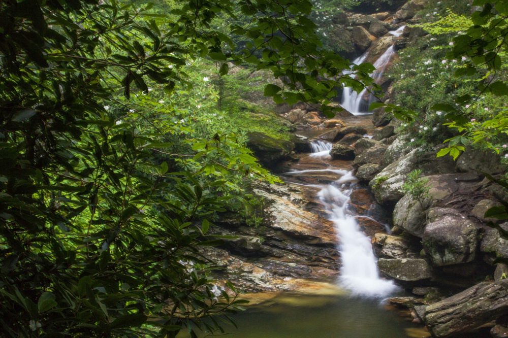
Skinny Dip Falls near the Blue Ridge Parkway in North Carolina
-
Devil’s Courthouse Summit Hike and Skinny Dip Falls
Nearest town: Canton, NC
Distance from Asheville: 1 hour
Distance between trailheads: 8 minute drive (5.2 miles)
Total Hiking Distance: 2.5 miles
This excursion makes our list as our favorite options for kids! Both Devil’s Courthouse and Skinny Dip Falls are popular destinations for locals and visitors alike. We recommend getting a bright and early start for your excursion, as both trails can be heavily-trafficked, particularly during the summer months.
Start your adventure with a drive along the scenic Blue Ridge parkway to the Devil’s Courthouse trailhead. Take the short, yet strenuous paved trail to the summit for some of the best panoramic views in the area. Along the way, be sure to notice the rare plants (endemic to high-elevation outcrops) surrounding you. Once arriving back at the trailhead, return the way you came on the Blue Ridge Parkway, stopping at Looking Glass Rock overlook MP 417 and the Skinny Dip Falls trailhead. Soak up stunning views of the iconic Looking Glass Rock before hiking along a short, idyllic forested trail to find the set of cascades and crystal clear pools that make Skinny Dip Falls a destination you simply do not want to leave! Enjoy a picnic and/or refresh in the cool mountain water after your summit hike.
Devil’s Courthouse
- Highlights: Panoramic view includes 4 states: North Carolina, South Carolina, Georgia, and Tennessee
- Elevation: 5,719 ft. (summit)
- Trailhead: Blue Ridge Parkway overlook (MP 422.4)
- Hike Distance: 1 mile round trip
- Difficulty: Moderate
Skinny Dip Falls
- Highlights: Crystal clear, turquoise pools for swimming
- Elevation: 4320 ft. (falls and swimming holes)
- Trailhead: Looking Glass Rock overlook (MP 417)
- Waterfall Height: 20 feet (tallest of 3 cascades)
- Hike Distance: 1.5 miles round trip
- Difficulty: Easy to moderate
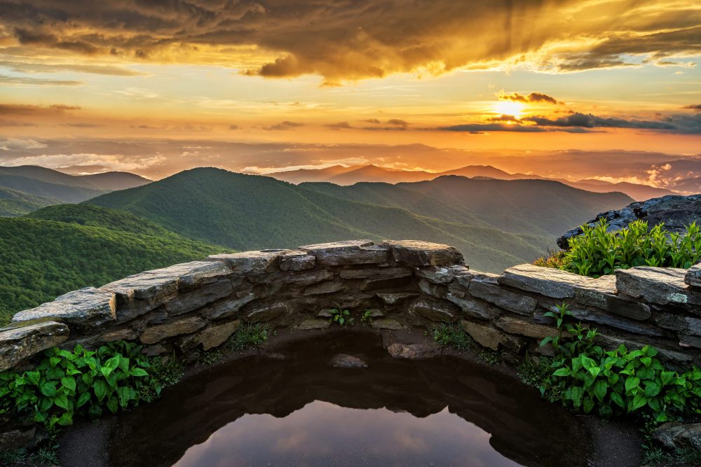
Sunset at Craggy Pinnacle with Great Smoky Mountains National Park in distance
-
Craggy Pinnacle Summit Hike and Douglas Falls/ Glassmine Falls
Nearest town: Barnardsville, NC
Distance from Asheville: Approximately 40 minutes
Distance between: 2 minute drive (0.6 mile)
Total Hiking Distance: See excursion options
This excursion offers two options with different intensities: easy/moderate and most difficult. For both options, we recommend hiking to the Craggy Pinnacle summit first and then exploring the waterfall of your choice.
Easier option: Craggy Pinnacle and Glassmine Falls: This hiking combo makes our list as one of the most enjoyable for sunrise/sunset hikes near Asheville, NC. Enjoy a round-trip hike to Craggy Pinnacle summit early morning to watch the sun climb over the mountains and then proceed along the Blue Ridge Parkway to MP 361.2, to see Glassmine Falls from the roadside overlook (best observed after periods of rain). For incredible sunset mountain views, reverse the order of your trip!
Most difficult option: Craggy Pinnacle and Douglas Falls: For our adventurers seeking some serious cardio and rugged terrain, this is the excursion for you. Accessing Douglas Falls from Craggy Gardens is exclusively recommended for very experienced hikers. Enjoy a deep backcountry trek and cool off by walking behind the lacey tendrils of this 70-ft waterfall. It is imperative you reference a more detailed resource for the description of this trail.
Very important note: There is a “lower approach” and an “upper approach” to Douglas Falls. The trailhead for the lower approach to Douglas Falls is nearly a 2-hour drive away from the Craggy Gardens trailhead! If a wildly challenging 8-mile hike does not sound like your cup of tea, yet you would still like to see Douglas Falls, we recommend you pursue the less strenuous lower approach to Douglas Falls and the Craggy Pinnacle hike in a separate day.
Craggy Pinnacle
- Highlights: Glacial relics, Rhododendron bloom in June/July
- Elevation: 5,892 ft. (summit), 5,660 ft. (trailhead)
- Trailhead: Craggy Dome overlook (MP 364.1)
- Hike Distance: 1.4 miles round trip
- Difficulty: Moderate
Douglas Falls
- Highlights: Overhanging, walk-behind waterfall and heart-pumping hike!
- Elevation: 4,200 (base of falls), 5,497 ft. (trailhead)
- Trailhead: Craggy Gardens Visitor Center (MP 364.6)
- Waterfall Height: 70 feet
- Hike Distance: 8 miles round trip
- Difficulty: Most strenuous
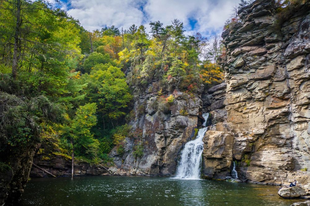
Linville Falls, along the Blue Ridge Parkway in North Carolina
-
Linville Falls and Babel Tower/ Wiseman’s View Summit Hike
Nearest village: Linville, NC
Distance from Asheville: Just over 1 hour
Distance between: 15 minute drive (3.5 miles)
Total Hiking Distance: See excursion options
This excursion places you in the awe-inspiring wildness of Linville Gorge— the steepest gorge east of the Grand Canyon! We recommend visiting Linville Falls via the Erwin trail first and then proceeding to Old NC 105 (or Kistler Memorial Highway) for the Babel Tower and Wiseman’s View hikes. For different approaches to Linville Falls, visit the National Park Service Linville Falls webpage for different trail options.
Easier option: Linville Falls and Wiseman’s View: The paved trail at Wiseman’s View is wheelchair, scooter, and stroller accessible, making it an incredible option for all the members of your group. With multiple overlooks, it provides several breathtaking aerial views of Linville Gorge as well as neighboring peaks, including Hawksbill and Table Rock mountains.
Strenuous option: Linville Falls and Babel Tower: The Babel Tower hike begins on the west rim of Linville Gorge, with a steep, rugged (unmarked) descent to the scenic Linville River and Babel Tower rock outcrop. Include the Wiseman’s View hike for multiple vantage points of Linville Gorge.
Babel Tower and Wiseman’s View
- Highlights: Old-growth forests of Linville Gorge Wilderness, panoramic views of Linville Gorge
- Elevation: 3,800 ft. (trailhead), 2,750 ft. (Linville River)
- Trailhead: Kistler Memorial Highway/Old NC 105
- Hike Distance: 2.6 miles out and back to Babel Tower, 0.4 miles out and back to Wiseman’s View
- Difficulty: Moderate to strenuous (Babel Tower), easy (Wiseman’s View)
Linville Falls (Erwin’s View Trail)
- Highlights: Four overlooks revealing different vantage points of Linville Falls, chimney-like rock outcroppings
- Elevation: 3,330 ft. (main overlook)
- Trailhead: Linville Falls Visitor Center
- Waterfall Height: 90 feet
- Hike Distance: 1.6 miles round trip
- Difficulty: Moderate
- Other nearby features: Hawksbill Mountain, Table Rock Mountain

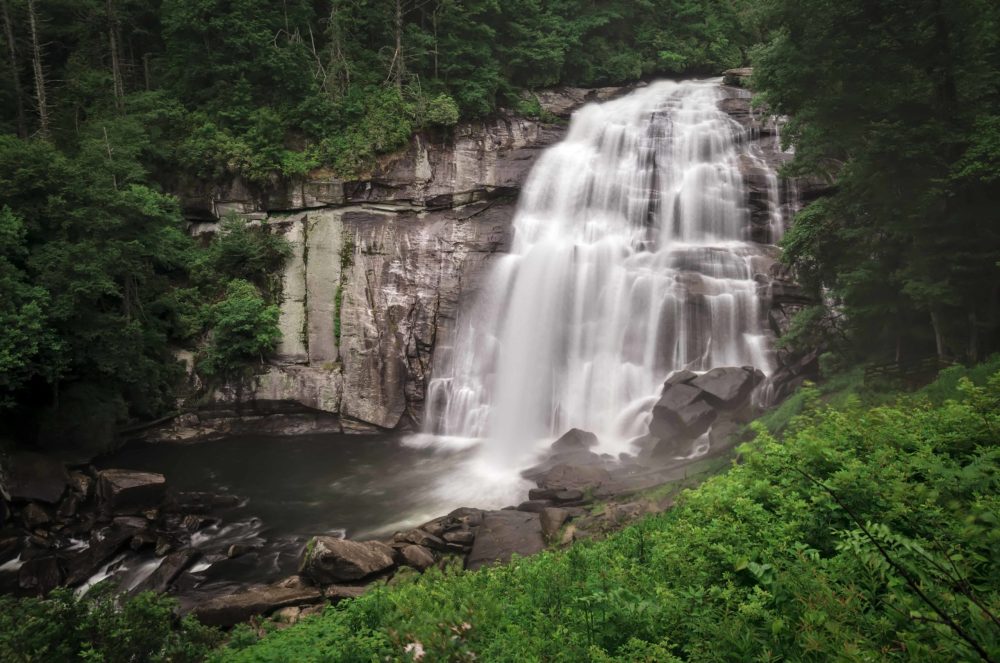
Hickory Nut Falls located in Chimney Rock State Park
-
Hickory Nut Falls and Exclamation Point Summit Hike
Nearest town: Chimney Rock, NC
Distance from Asheville: 45 minutes
Distance between: None. Both trails begin at upper parking area.
Total Hiking Distance: See excursions options
This excursion is the only hiking combo on our list that does not require car travel to a separate trailhead in between hikes. It is also our favorite option for the entire family to enjoy. Leased dogs welcome. Note: there is a fee to enter Chimney Rock State Park and a park representative will provide you with a trail map. We recommend taking a shuttle to the upper parking area for easier access to both the Otis Elevator/Outcroppings trail and the Hickory Nut Falls trail.
The Hickory Nut Falls trail is an easy/moderate, out and back trail with a slight grade uphill to the base of the falls. The Otis elevator takes guests up to the Sky Lounge patio located near the top of the Chimney— making this our most accommodating excursion. Check with Chimney Rock State Park’s website to learn if the elevator is operating at the time of your trip. Alternatively, you can walk to the Chimney via the Outcroppings trail. The Exclamation Point trail is accessed from the junction at the Chimney and leads you to the highest point in Chimney Rock State Park!
Strenuous option: For those who wish to walk the entirety of this excursion, versus using the shuttle and elevator, begin at the lower parking area, take the Four Seasons trail, then Hickory Nut Falls trail to the base of the falls, return the way you came and proceed past the Four Seasons trail junction. You will then find a network of stairs on the right that will take you to the Outcroppings trail.
Exclamation Point
- Highlights: Highest point in Chimney Rock, panoramic views of Hickory Nut Gorge and Lake Lure
- Elevation: 2,480 ft. (Exclamation Point)
- Trailhead: Trail junction at base of Chimney
- Hike Distance: 0.6 mile round trip from the Chimney
- Difficulty: Moderate to strenuous
Hickory Nut Falls
- Highlights: One of the tallest waterfalls east of the Mississippi, wildlife sightings
- Elevation: 2080 ft.
- Trailhead: Upper parking area
- Waterfall Height: 404 feet
- Hike Distance: 1.4 miles round trip from upper parking area
- Difficulty: Moderate
- Other nearby features: Skyline Trail, Rumbling Bald
Rainbow Falls in Pisgah National Forest, near Gorges State Park in North Carolina
-
Rainbow Falls/ Turtleback Falls and Whiteside Mountain Summit Hike
Nearest town: Cashiers, NC
Distance from Asheville: 1 hour and 15 minutes
Distance between: 34 minutes (18.7 miles)
Total Hiking Distance: Approximately 6 miles
This final excursion makes our list as the most grandiose option of all! While this hiking duo is the longest distance from Asheville and also the greatest distance from one another, the extra driving time is worth it.
We recommend first exploring Whiteside Mountain. This 2-mile, moderate loop trail features 750-ft sheer cliffs, spectacular wildflowers, lush northern hardwood and montane oak forests, sweeping mountain views, and more. As you proceed along the route, you will find educational signs describing Whiteside Mountain’s history as a tourist attraction in the early 20th century. Depending on what time of year you visit, you may be lucky enough to spot peregrine falcons. Whiteside Mountain’s rock outcrops serve as an ideal nesting habitat for this spectacular and beautiful bird.
Next, reverse directions as if headed back to Asheville and continue your excursion with a visit to stunning Rainbow Falls and Turtleback Falls, near Gorges State Park. Visiting the 150-ft Rainbow Falls is an invigorating experience for all the senses! Listen as the waterfall roars and crashes into giant boulders below, feel the cool mountain water, smell the abundant wildflowers, and watch as the sun pierces the clouds of mist and creates vibrant rainbows. The moderate, out and back trail to Rainbow Falls runs along the peaceful Horsepasture River and offers views of magnificent water features throughout. After walking 1.5 miles to view Rainbow Falls, you have the option to press forward just 0.25 miles more to see Turtleback Falls. Please always keep in mind the incredible power of these waterfalls and always exercise supreme safety when walking along slippery surfaces.
Whiteside Mountain
- Highlights: Hanging garden in seepage wetland, peregrine falcon nesting grounds
- Elevation: 4,930 ft. (summit); 4,440 ft. (trailhead)
- Trailhead: Whiteside Mountain parking area
- Hike Distance: 2 miles round trip
- Difficulty: Easy to moderate
Rainbow Falls and Turtleback Falls
- Highlights: Ranging waterfalls
- Elevation: 2640 ft.
- Trailhead: Grassy Ridge Parking Area in Gorges State Park
- Waterfall Height: 150 feet (Rainbow Falls)
- Hike Distance: Approximately 3.75 miles round trip
- Difficulty: Moderate
- Other nearby features: Drift Falls, Hidden Falls
Now, let’s prepare! Essential hiking gear to take with you: hiking sandals and/or sturdy footwear (depending upon hike difficultly), extra layers (wind breaker or rain jacket preferred), plenty of food and plenty of water, first aid kit, compass, maps, dry bag (for any non-waterproof electronic or other items), GPS device (optional, but very handy).
We highly recommend for smart phone users that you download navigation apps, such as AllTrails or Gaia GPS before setting out on your adventure. From inside the app, download maps of your trail before you could potentially lose service! For many of the hikes, there are kiosks with a map of the area at the trailhead— take a photograph with your phone or camera… always. Kevin Adams has a detailed map of over 300 North Carolina Waterfalls as well as a North Carolina Waterfall book showcasing his incredible waterfall photography. The hike descriptions below provide a general overview of your itinerary with each excursion and the highlights of each hike; therefore, it is recommended you reference more detailed descriptions such as Romantic Asheville, particularly for more strenuous hikes.
Before you hit the trail, it is important to pay tribute to the incredible biodiversity of the Southern Appalachian Mountains. The Southern Appalachians are considered to be one of the most biodiverse regions of the world, largely attributable to the region’s topography and climate as well as the movement of species with Pleistocene, “Ice Age,” glaciation events, approximately 11,000 years ago. The Southern Appalachian ecoregion is a brilliant mosaic of habitats, projected to be home to over 10,000 species with many new species to be discovered. Many, if not all, of the hiking destinations visited within our five excursions are habitats for rare, endemic plant species, and some, breeding grounds for exquisite and sensitive animals, such as peregrine falcons. Be mindful of your step and stick to designated trails for your own safety and for these plants and animals. For further information regarding the biodiversity of the Southern Appalachians, check out the Southern Appalachian Highlands Conservancy or Highlands Biological Station to learn about the ongoing conservation efforts and research of local non-profits and affiliated groups.
Natural Notes is Asheville Hiking Tours’ blog about nature, history and travel in the Appalachians. Asheville Hiking Tours offers day hikes, waterfall tours, and firefly tours, guided by naturalists, in the mountains around Asheville, NC. For more info visit www.AshevilleHikingTours.com.